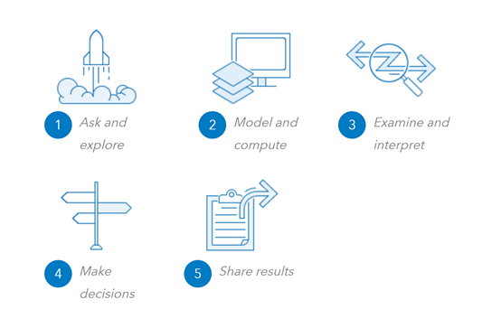
Many problems in the world today can be solved using the spatial problem solving approach.

1. Ask and explore
- Set the goals for your analysis. Begin with a well-framed question based on your understanding of the problem. Getting the question right is key to deriving meaningful results. Questions that can be answered using spatial analysis include:
- How many are in an area?
- Which sites meet my criteria?
- What are the characteristics of an area?
- How is it distributed?
- What is near what?
- What is on top of what?
- How is it related?
- Explore and visualize your data to refine and scope the question that you want to address. Exploring your data will shed light on aspects of the question that you may not have considered, prompting you to further refine your question.
2. Model and compute
- Choose an analysis tool to transform your data into new results or build a model of multiple tools to feed the results of one tool into the next.
- Process the data analytically to derive essential information that helps you answer your question.
3. Examine and interpret
- Manipulate and display the results of your analysis as information products, such as maps, reports, charts, graphs, and information pop-ups.
- Seek explanations for the patterns you see and speculate about what they might mean from a spatial or temporal perspective.
- Assess whether the results of the analysis provide an adequate answer to the question you asked. If not, you may need to adjust your approach. Is your question too broad or too narrow? Do you require more or different data? Should you use more or different analysis tools?
- Determine whether assumptions about the data, analysis methods, and mapping methods would alter the results. Also consider what artifacts of the data, analysis, and mapping processes deserve special attention.
4. Make decisions
- Document your interpretation of the analysis results and decide how to respond.
- In some cases, you can take action based on your interpretation of the results. Implement a solution, correct a situation, create an opportunity, or mitigate circumstances.
- In other cases, no action is required because your goal was to build knowledge and gain a deeper understanding.
- Often new questions arise that need to be addressed. These new questions will often lead to further analysis.
5. Share your results
- Identify the audience that will benefit from your findings and determine who you want to influence. Then use maps, pop-ups, graphs, and charts that communicate your results efficiently and effectively.
- Share those results with others through web maps and apps that are geoenriched to provide deeper explanation and support further inquiry.
This description of the spatial problem solving approach is a simplification, in large part because problem solving isn't linear. The actual process will be much more involved. You will iterate, diagnose, and review as you gain new insights and understanding along the way, prompting you to rethink your approach.